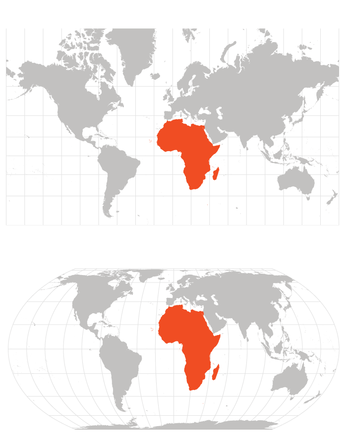

The United Nations General Assembly voted Friday to adopt a resolution urging countries to replace the centuries-old Mercator map with projections that show Africa’s true, larger size, a change that would make Africa appear dramatically larger and North America and Europe comparatively smaller.
The “Correct the Map” resolution, led by Togo and the African Union, passed 164 to one. The United States cast the only vote against it, while six countries abstained.
What the resolution does
The resolution is not legally binding and does not require countries or institutions to abandon the Mercator projection, one of the world’s most widely used maps. Instead, it encourages wider adoption of equal-area projections—such as the Equal Earth projection—which render continents in their correct proportional sizes, even though their shapes are somewhat distorted as a trade-off.
The text also calls for cooperation among UN bodies, regional organizations, academia, and technology groups to strengthen national mapping capabilities and support cartographic research, particularly in developing countries and across Africa.
The Mercator projection, created by Flemish cartographer Gerardus Mercator in 1569, was originally designed as a navigational tool that let sailors plot straight-line courses while maintaining a constant compass bearing. But because it stretches areas near the poles while compressing those near the equator, it has long been criticized for inflating the apparent size of Europe and North America while shrinking Africa, South America, and other equatorial regions.
Why Africa pushed the measure
Togo’s Foreign Minister, Robert Dussey, told the General Assembly ahead of the vote that maps are far more than neutral depictions of geography—they shape education, imagination, and how people perceive the world. He argued that the long-standing distortion has helped symbolically diminish Africa’s stature on the global stage and produced an unbalanced view of world geography.
The African Union celebrated the outcome, saying in a statement that the resolution would promote equal-area maps like Equal Earth in classrooms, media, and international institutions so that world maps finally reflect Africa’s true scale and place in the world. Carlos Lopes, a University of Cape Town professor and prominent advocate of the Correct the Map campaign, called the result an emotional milestone after years of advocacy.
The Equal Earth projection itself was developed in 2018 by a team of cartographers; one of its creators reacted with surprise on social media that the map had become the centerpiece of a UN resolution.
Washington’s objection
The United States was the sole “no” vote and used the debate to sharply criticize the resolution. A US representative argued the General Assembly should be focused on more pressing global problems rather than debating centuries-old map projections and their symbolic ties to reparations discourse.
US officials characterized the initiative as part of a broader ideological push rather than a simple technical update to cartographic proportions and argued that such debates undermine the credibility of the institution.
International reaction
France, which co-sponsored the resolution, announced Friday that it would abandon the Mercator projection in its own official use. Six other countries abstained from the vote, though the specific abstaining nations were not detailed in available reporting.
The vote does not compel any government, school system, or media organization to change the maps they use, but supporters hope the symbolic UN endorsement will accelerate a broader shift toward equal-area projections in classrooms and publications worldwide.